PROJECTS
REAL PROJECTS. REAL CONDITIONS. REAL DELIVERABLES.
Every project SpaceDoc360™ takes on starts with the same commitment: capture what actually exists, document it accurately, and turn that information into something the project team can use.
EXISTING CONDITIONS + ADAPTIVE REUSE
45,000 SF EXISTING FACILITY | 3D REALITY CAPTURE | AS-BUILT DOCUMENTATION | ADAPTIVE REUSE
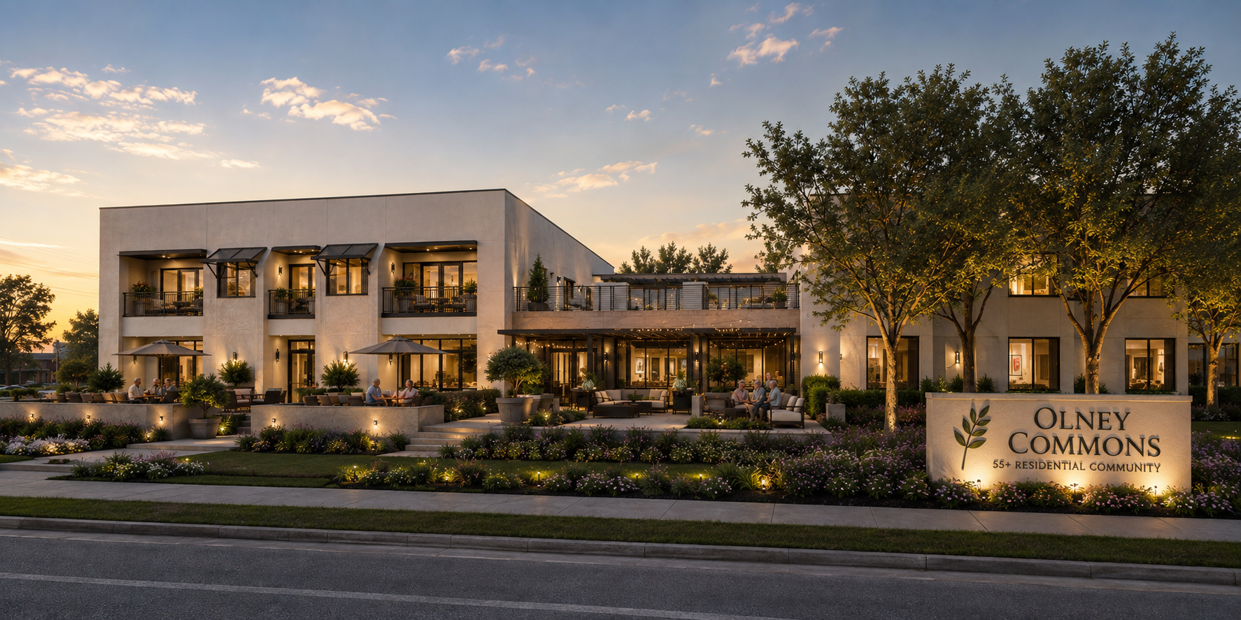
SpaceDoc360™ was engaged to document an approximately 45,000-square-foot, two-story existing facility in Olney, Texas as part of a redevelopment effort being advanced in conjunction with The Twiin Group, LLC and the local Economic Development Corporation.
The Twiin Group, LLC, led by Steven Turner, was founded to meet the growing need for modular construction expertise that responsibly integrates project feasibility, entitlements, proper supply chain sourcing and effective design with traditional general construction. SpaceDoc360 is providing the existing-condition reality capture and documentation needed to establish an accurate baseline for planning and design.
The Twiin Group, LLC: https://thetwiingroup.com/
The objective is to help reposition an existing underutilized property into a proposed 55+ residential community, giving the project team reliable existing-condition information needed to evaluate the building, develop the renovation strategy, coordinate design, and move the project forward.
The collaboration brings together The Twiin Group's project-development experience and SpaceDoc360's reality capture, as-built documentation, and design capabilities—creating a more efficient path from an existing building to redevelopment planning.
PROJECT DETAILS
LOCATION
Olney, Texas
FACILITY SIZE
~45,000 SF
STORIES
Three
PROJECT TYPE
Adaptive Reuse
SERVICES
3D Reality Capture, As-Built Documentation
PROJECT COLLABORATION
SpaceDoc360™ + The Twiin Group, LLC + Local Economic Development Corporation
THE CHALLENGE
BEFORE YOU CAN DESIGN WHAT'S NEXT, YOU HAVE TO KNOW WHAT'S THERE.
Adaptive reuse begins with understanding the existing building.
Large facilities—particularly buildings that have undergone years of modifications—can present significant challenges when original drawings are unavailable, incomplete, or no longer accurately represent field conditions.
Traditional documentation of a building of this size can require extensive manual measuring, photographs, field sketches, repeated site visits, and considerable time reconstructing existing conditions before meaningful planning and design can begin.
For the Olney project, SpaceDoc360 used a comprehensive reality-capture workflow to create a digital record of the existing facility and establish a reliable foundation for the next phase of redevelopment.

CAPTURE ONCE. USE THE DATA THROUGHOUT THE PROJECT.
The two-story facility was systematically documented using 3D reality capture, 360° imagery, dimensional data, and field verification.
Instead of relying solely on individual measurements and field notes, the capture process creates a navigable digital record of the building that can continue to be referenced after the initial site documentation is complete.
Captured information is processed, organized, and transformed into usable existing-condition documentation that can support the development of as-built floor plans, CAD drawings, space planning, engineering coordination, and design.
When questions arise later, the project team can return virtually to documented areas of the building to review visible conditions, verify information, and better understand relationships within the existing facility.
This reduces dependence on repeated manual measurements and return visits while allowing planning and design teams to work from a much more complete record of the property.
For a redevelopment project of this scale, that means less time reconstructing the existing building and more time working on what comes next.
EXPLORE THE PROJECT
STEP INSIDE THE EXISTING CONDITIONS
The SpaceDoc360 documentation process creates more than measurements and drawings.
The project's 360° capture provides a navigable visual record of the existing facility, allowing owners, designers, engineers, contractors, and other project stakeholders to virtually return to documented spaces throughout planning and design.
Instead of relying on scattered photographs or sending someone back to the property every time a question arises, the captured environment becomes a persistent digital project resource.
An interactive virtual tour of the Olney facility will be available here, demonstrating how reality capture can support an adaptive-reuse project long after the initial site visit.
INTERACTIVE 3D / 360° VIRTUAL TOUR
COMING SOON
FROM REALITY CAPTURE TO PROJECT DATA
01
CAPTURE
DOCUMENT THE EXISTING FACILITY
Systematically capture the existing two-story building using 3D scanning, 360° imagery, dimensional information, and field verification.
02
PROCESS
BUILD THE DIGITAL RECORD
Process and organize captured spatial and visual information into a comprehensive digital representation of existing conditions.
03
DOCUMENT
CREATE USABLE AS-BUILTS
Translate captured conditions into floor plans, existing-condition drawings, and CAD-ready project information.
04
DEVELOP
PROVIDE THE FOUNDATION FOR WHAT'S NEXT
Give The Twiin Group and the project team reliable existing-condition information to support space planning, architectural development, engineering coordination, renovation decisions, and redevelopment of the property.

HELPING MOVE REDEVELOPMENT FORWARD
For an adaptive-reuse project, accurate existing-condition documentation is more than a record of a building.
It becomes the starting point for design.
By establishing building geometry and documenting existing spaces early in the process, SpaceDoc360 helps the project team spend less time reconstructing what exists and more time evaluating what the property can become.
The resulting information can support space planning, architectural development, engineering coordination, renovation decisions, preliminary construction evaluation, and communication among The Twiin Group, the Economic Development Corporation, consultants, contractors, and other project stakeholders.
For communities working to return existing properties to productive use, reality capture can help remove one of the earliest obstacles to redevelopment:
NOT KNOWING EXACTLY WHAT YOU HAVE TO WORK WITH.
With the existing conditions captured and documented, the conversation can move from "What is there?" to "What can we do with it?"
THE SPACEDOC360 APPROACH
45,000 SF. TWO STORIES. ONE DIGITAL EXISTING-CONDITION RECORD.
The Olney project demonstrates the same approach SpaceDoc360™ brings to every project:
Capture existing conditions accurately. Preserve them digitally. Transform that information into usable documentation. Then use that information to help move the project forward.
And that approach isn't limited to 45,000-square-foot buildings.
From a single room, tenant space, residence, or targeted area to a multi-story facility, industrial property, commercial development, marine structure, or major redevelopment, the SpaceDoc360 process can be scaled around the project and the information required.
NO PROJECT IS TOO BIG OR TOO SMALL.
Whether you need one critical space documented, an entire facility captured, accurate as-built drawings developed, construction progress recorded, insurance-loss conditions documented, or existing conditions carried all the way into design, SpaceDoc360 can build the scope around what you actually need.
ONE SPACE OR AN ENTIRE FACILITY.
ONE VISIT OR AN ONGOING PROJECT.
CAPTURE IT ONCE. USE IT THROUGHOUT THE PROJECT.
SCAN IT. DOCUMENT IT. DESIGN FROM IT.
WE SCAN. YOU PLAN.™